The trekking trail connects Sappada to Tarvisio and, over the course of its 200 km, covers the long and articulated main Carnic Ridge, connecting the malghe, farmhouses and shelters of the Italian and Austrian flank. The itinerary, which can be travelled in both directions, includes dirt roads, trails and old mule tracks and is not a particularly complicated trek.
HOW TO GET THERE: can be reached from Ugovizza via the road that heads to the Val Uqua and then via the track of the CAI 507 trail.
HOW TO GET THERE: take Trail No. 132 (2-3 hours, Easy hiking trail) from Cima Sappada or take Trail No. 137 (2 hours, Easy hiking trail) from Val Visdende. Alternatively, you can travel along the road in an off-road vehicle from Cima Sappada until you reach the Springs of the Piave River and then take Trail No. 132 (1 hour, Easy hiking trail).
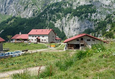
HOW TO GET THERE: by car, motorbike or bike, take the road that leads from Forni Avoltri to Collina and then to Plan Val di Bos, where the mountain hut is situated. On foot: Walk along the CAI 143 trail from the Marinelli Mountain Hut, and the CAI 144 trail from the Lambertenghi Mountain Hut. Camping area, guided hikes. Wi-Fi service
HOW TO GET THERE: from the Forni Avoltri direction: take the CAI 143-signposted dirt road from the Tolazzi Mountain Hut, and you will reach the Mari- nelli Mountain Hut in 2 hours. From the Paluzza direction: take the SS52-bis road towards the Plöcken Pass and take the dirt road on the left just before you reach the bor- der. Follow the CAI 146 signposts for the Tra- versata Carnica. The road immediately beco- mes a trail and you will reach the mountain hut in 2.5 hours. Alternative route: from the Plöcken Pass on the CAI 146/148 trails. This is the difficult La Scaletta pass where equip- ment is required and the Monumenz. You will arrive in 3 hours after passing the Plotta Lake.
The malga was recently restructured, while retaining its original architectonic characteristics. Nearby, you can visit Lake Malins and observe the many newts that inhabit its waters. This picturesque Alpine landscape is particularly suggestive, due to a gorgeous view of the Pesarine Dolomites. By proceeding left from the shelter, you can reach malga Vinadia Grande and then descend towards the Pesarine Valley.
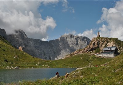
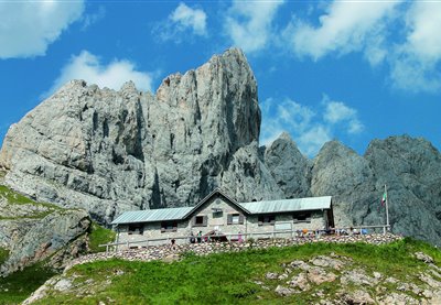
The Carnic Alps hold a wealth of surprises in store for active explorers. One of them is Lake Wolayersee on the Carinthian side of the Carnic main ridge, near Plöcken Pass. On sunny days, the peaks of Hohe Warte, Seewarte and Seekopf are reflected in the glittering, turquoise-coloured waters of the lake. The lake is a geological peculiarity, as it is not fed by a spring, but consists of rain and meltwater that collects in a doline dating back to the Ice Age. Normally, this water would seep away through the rock, but here, it doesn't - much to the delight of modern-day hikers, who are able to enjoy the beautiful views across this idyllic mountain lake. A leisurely "Jause" with regional delicacies on the terrace of Wolayersee hut, gazing across the waters of the lake and the surrounding mountains, is a perfect way to while away the hours. But this popular day trip destination has even more to offer: the hut has several rooms and a dormitory with mattresses and is an important base for long-distance hikers on the Karnischer Höhenweg trail as well as passionate climbers, with two via ferratas leading up Hohe Warte. Hikers who prefer a less hair-raising approach can find out plenty of fascinating facts about the formation of this imposing mountain panorama on the geotrail. Wolayersee hut is a two and a half hour walk from Hubertuskapelle chapel in Wolayertal valley and a three-hour walk from the Untere Valentinalm pasture on Plöcken Pass.
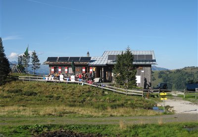
Zollnersee hut is operated by the Austrian Alpine Association and lies nestled against the beautiful pastures right next to the Italian border, between Plöcken Pass and Nassfeld. It is a fixture for long-distance hikers along the Karnischer Höhenweg trail as well as for day trippers staying in the region. The Zollnersee region is also highly recommended for families as it may be reached on foot, by mountain bike or by car. Its name derives from nearby Lake Zollnersee, accessible directly from the hut via gentle walking paths that lead across a moor. In 2015, the region with its geotrails was awarded the UNESCO Global Geopark logo. Lake Zollnersee itself is the perfect destination for travelling through time, back to the Palaeozoic age, and a real-life geology lesson. Zollnersee hut itself received an award in 2018, when it became the first Slow Food Travel Hut along the main ridge of the Alps, serving only regionally sourced farm products - quality you can taste! For a full-day programme, the locals recommend a detour to Rifugio Fabiani via Zollnertörl. The nearest summits of the Kleiner Trieb, the Hoher Trieb and the Findenig offer one-of-a-kind views of the mountain panorama of the Carnic Alps. If you would like to spend the night in Zollnersee hut, make camp in the dormitory with mattresses or in one of the two double rooms. After a wonderful mountain breakfast, pay a visit to Rosser hut, where Gailtaler Almkäse and other dairy products are made from scratch throughout the summer. Yet another must-see is the Chapel of Peace, built in memory of the turmoil of World War I - an architectural gem that fits in beautifully with the surrounding landscape.
The pasturing area - which consists of various environments, the grazing space, the buildings, the wood and the waterholes - is frequented by numerous bird species, such as black redstarts and yellowhammers that find ideal feeding and nesting conditions in this area. However, the large amount of small birds also attracts their most deadly predator, the Eurasian sparrowhawk. By proceeding beyond the shelter, you will reach malga Pieltinis and the homonymous mountain (CAI trail n. 206).
CAI trail n. 402, which connects Pramosio to Malpasso, features the memorial plaque dedicated to Maria Plozner Mentil, killed while carrying supplies to the frontline. Her story and that of all Carnic Bearers was progressively forgotten up until 1997, when the former President of the Italian Republic Scalfaro awarded these historical figures with the Gold Medal for Military Valour. From the Pramosio Pass you can visit numerous First World War sites and structures such as tunnels, trenches and posts. Malga Pramosio is the location of the only medieval mining tunnel in the eastern Alps, still intact in its original state. By proceeding beyond the shelter on CAI trail n. 402, you can reach the Malpasso ricovero Morgante shelter, the shelter of the Manze and, at an even higher altitude, the Upper Pramosio shelter with the splendid Lake Avostanis, surmounted by one of the most beautiful cliffs in the eastern Alpine range.
The pastures of malga Pieltinis cover the entire East flank of the homonymous mountain and the valley line beneath the peak features one of the richest heath areas in the whole Carnic Alps range. In addition to Alpine rhubarb, the meadows next to the malga also feature Alpine Timothy-grass, dandelions and specimens of Campanula scheuchzeri. From the Pieltinis shelter visitors can climb rightwards, traverse the Ielma pass and descend towards the Ielma di Sopra and Ielma di Sotto malghe before reaching the Pesarine Valley (CAI trail nThe pastures of malga Pieltinis cover the entire East flank of the homonymous mountain and the valley line beneath the peak features one of the richest heath areas in the whole Carnic Alps range. In addition to Alpine rhubarb, the meadows next to the malga also feature Alpine Timothy-grass, dandelions and specimens of Campanula scheuchzeri. From the Pieltinis shelter visitors can climb rightwards, traverse the Ielma pass and descend towards the Ielma di Sopra and Ielma di Sotto malghe before reaching the Pesarine Valley (CAI trail n. 218); turn leftwards from the lodges to traverse the Pieltinis pass and descend towards the Vinadia Grande malghe (CAI trail n. 204).. 218); turn leftwards from the lodges to traverse the Pieltinis pass and descend towards the Vinadia Grande malghe (CAI trail n. 204).
The Montasio plateau, a place of extraordinary beauty, is the largest grazing area in the entire region. The following malghe are all located in this district: Cregnedul di sopra, Larice, Parte di Mezzo and Pecol, dedicated to cheese production and agro-tourism. The history of the area describes the birth of Montasio cheese at the start of the thirteenth century, thanks to the Benedictine monks from Moggio Udinese. From a naturalistic point of view, in this area visitors can encounter rooster combs, broom flowers, marmots, deer, chamois, roe deer and foxes. From the Plains of the Montasio, you can return to Sella Nevea and descend towards Tarvisio via the town of Cave del Predil with its charming lake. Starting from the Pecol shelter, you can also easily reach the Giacomo Di Brazzà Refuge (on CAI trail n. 622), a splendid balcony looking onto the Mount Canin range.
In 1478, on Plan di Lanze, a violent battle took place between the Turks – who were trying to cross the pass – and Venetian troops flanked by Carnic militias. The Turks were defeated and pushed back, and the Carnia area was therefore saved from their dreaded raids. According to legend the name, Plan di Lanze, derives from the lances abandoned on the battlefield by the defeated Turks. A didactic rocky gym has been built at a distance of just approximately one hundred metres from the shelter. This site offers a magnificent view of Mount Zermula and of the Creta di Aip. The shelter is the ideal starting point for many excursions, including climbs towards Mount Zermula (2.143 m) (CAI trails n. 442 and 442A), or towards the Lomasti bivouac, via malga Val Dolce and the Aip Valley (CAI trails n. 439 and 440).
A sparkling blue sky, lush green mountain pastures, a far cry from the hustle and bustle of the outside world - and yet so close: Dellacher Alm pasture is the perfect destination for all those yearning for a break from the everyday routine and keen to replenish their energy levels by going offline in a beautiful mountain setting. Up here, there is no mobile phone, radio or television signal. Entertainment is provided by nature, and nothing else. However, there is no question of things getting boring: kids can roam around and let off steam to their heart's content, the adults can have a chat at the fountain or soak up the sun on the little bench outside the hut. Dogs are also welcome up here. If you really can't bear the thought of leaving so soon, simply rent one of the 25 huts available. In total, Dellacher Alm consists of 36 huts, original structures made from stone and timber. Some even come with a traditional roof made of wooden shingles, such as the Almgasthaus inn that is run by the Pipp family, where guests are treated to regional delicacies such as the Gailtaler Almkäse cheese or freshly made butter. No one has ever left this place hungry! Dellacher Alm pasture is easily accessible via Egger Alm pasture - simply follow the road past wildly romantic Lake Almsee. After an approximately 3.5km walk, you will reach the pasture of Dellacher Alm, which also makes a great starting point for hikes, for instance up the Poludnig peak and Poludnig Alm pasture.
Just a few steps uphill from Egger Alm pasture is the perfect spot for having a rest on the mountain meadow, amidst blooming herbs and with wonderful views to boot. Let your gaze wander across the 47 huts, the veterans' chapel of the mountain village, the lush forests and further on across Lake Presseggersee to the other side of the valley, where the Gailtal Alps present themselves from their best angle. But it is not just the wide-open vistas that make this high valley with its little mountain lake so unique. The hummocky meadow is bursting with vegetation and the cows can take their pick of tasty grasses and herbs, making for particularly flavoursome dairy products, starting with Gailtaler Almkäse (Protected Designation of Origin). The pasture has a long cheese-making tradition and cheese is prepared here as it was a hundred years ago, with plenty of love and time. Visitors are welcome to take a peek at the cheese-making facilities. The inn on Egger Alm pasture is the perfect place for sampling award-winning cheeses, not just cold on a platter, but also in hot dishes such as cheese soup or "Kaspressknödel" dumplings. Fresh mountain butter, "Schotten" cheese, yoghurt and curds are also on the menu. Kids will appreciate the playground and being free to roam the surrounding area. At the end of July and the beginning of August, the annual cheese-cutting ceremony is celebrated with a Kirchtag festival directly on the pasture!
Really switch off, take a deep breath, live in the moment - Straniger Alm pasture, nestled against a breathtaking natural backdrop near the border to Italy, is the perfect place to do just that. The pasture may be reached via a well-maintained gravel path. For long-distance hikers, the pasture on the southern mountain ridge of the Gailtal valley is a great place to rest and one of the most important overnight stops on the Karnischer Höhenweg trail and the Via Alpina between Plöcken Pass and Nassfeld Pass. For mountain bikers, Italy is just a short ride away. Hikers may continue on the cheese-themed circular trail, visit nearby Kordin Alm pasture, or make their way up Waidegger Höhe, Schulterkofel or Hochwipfel mountain. To top up your supplies or purchase some goodies to take home with you, pay the small farm shop a visit. The pasture is farmed by a community from the surrounding villages. Traditional dairy skills are still cultivated on Straniger Alm: Gailtaler Almkäse is made, matured and stored here based on an original recipe. The cheese that owes its savoury note to a small amount of goat's milk is left to ripen in a natural rind. The ancient knowledge of cheese-making is passed on here through workshops and courses. Tours of the pasture, including tastings of its various products, are also organised on a regular basis. Visitors can expect lovingly and creatively prepared dishes, using produce straight from the farm. The pasture and its hut are known for their convivial, relaxed air. Guests quickly turn into friends who return time and time again!
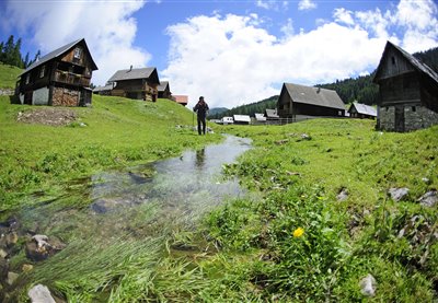
HOW TO GET THERE: you can comfortably arrive by car from Sappada, or you can arrive on foot via a trail that crosses through a Norway spruce forest. Take the road that passes between the village’s houses in Cima Sappada, until you reach the turn for the Springs of the Piave River and Val Sesis. After a short uphill ramp, cross the main road and then take the trail that leads straight to the glacial sediments, where the Piave River flows. It takes 45 minutes to reach the Piani del Cristo Mountain Hut from Cima Sappada.